
[<<< Previous Image] [KentuckyRoads.com - Maps] [Next Image >>>]
Location: Northeast of Owensboro
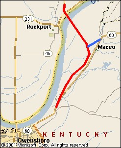
A map of northeast Daviess County, KY and southern Spencer County, IN showing the general area of the new US 231 and US 60. The bright red line is the four lane divided highway approach to the William H. Natcher bridge. The blue lane is a connector for US 60.
The routes from this map were approximated using this KYTC map of Daviess County ![]() .
.
Image Gallery: KentuckyRoads.com - Maps
[<<< Previous Image] [KentuckyRoads.com - Maps] [Next Image >>>]
Featured Items: [About this Site] [Hal Rogers Parkway] [Clay's Ferry Bridge] [Glen Lily Road Overpass] [Suggested Links] [Travel Information] [William H. Natcher Bridge]
| Copyright © 2001-2023 by Jeffrey Carlyle. All rights reserved. This website is not associated with any government agency. |