Home > Image Library > KentuckyRoads.com - General Images >
bg_exit59

[<<< Previous Image] [KentuckyRoads.com - General Images] [Next Image >>>]

Blue Grass Parkway Exit 59 (old configuration)

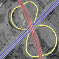
This diagram superimposed on a terraserver image show the typical configuration of interchanges at toll plaza's on Kentucky's parkways.

In this image, US 127 (indicated in red) crosses over the Blue Grass Parkway (indicated in blue) at exit 59 near Lawrenceburg. The toll booths were situated undernearth the US 127 overpass. The ramps (indicated in yellow) are arranged in a four-leaf clover formation: this was so that one set of toll booths could be used for thru -taffic, traffic exiting the parkway, and traffic entering the parkway.

As of early 2004, construction was underway to convert this particular interchange into a traditional diamond interchange [Outside Link].

Related news topics: [Anderson County] [Martha Layne Collins Blue Grass Parkway] [US 127]

Image Gallery: KentuckyRoads.com - General Images

[<<< Previous Image] [KentuckyRoads.com - General Images] [Next Image >>>]

Updated: 7-Feb-2004 11:59PM CST

Note: This website makes heavy use of the CSS standard. Your browser appears not to support CSS, or you may have CSS turned off for some odd reason. This page may render incorrectly since you are not using CSS. (more information on CSS)

Featured Items: [About this Site] [Hal Rogers Parkway] [Clay's Ferry Bridge] [Glen Lily Road Overpass] [Suggested Links] [Travel Information] [William H. Natcher Bridge]

Copyright © 2001-2023 by Jeffrey Carlyle. All rights reserved. This website is not associated with any government agency.