Home > Image Library > Wendell H. Ford Western Kentucky Parkway - Miscellaneous Images >
oldconnector

[<<< Previous Image] [Wendell H. Ford Western Kentucky Parkway - Miscellaneous Images] [Next Image >>>]

Western Kentucky Parkway's Old Connector: Overview

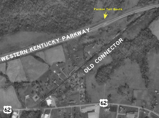
This USGS aerial photograph obtained from TerraServer [Outside Link] shows the layout of the old connector route at the former western terminus of the parkway. The diagonal line is the old connector route. Several houses have been built along the old connector.

More information: Western Kentucky Parkway’s Abandoned Connector

Photograph taken on February 22, 2004 by Jeffrey Carlyle.

Related news topics: [Caldwell County] [US 62] [Wendell H. Ford Western Kentucky Parkway]

Image Gallery: Wendell H. Ford Western Kentucky Parkway - Miscellaneous Images

[<<< Previous Image] [Wendell H. Ford Western Kentucky Parkway - Miscellaneous Images] [Next Image >>>]

Updated: 24-Feb-2004 10:28AM CST

Note: This website makes heavy use of the CSS standard. Your browser appears not to support CSS, or you may have CSS turned off for some odd reason. This page may render incorrectly since you are not using CSS. (more information on CSS)

Featured Items: [About this Site] [Hal Rogers Parkway] [Clay's Ferry Bridge] [Glen Lily Road Overpass] [Suggested Links] [Travel Information] [William H. Natcher Bridge]

Copyright © 2001-2023 by Jeffrey Carlyle. All rights reserved. This website is not associated with any government agency.